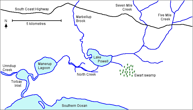
Except for a few small, short coastal streams, the major streams which drain most of the Torbay catchment flow into the Torbay lakes system. Before European settlement, Five Mile Creek joined Seven Mile Creek to empty into the east side of Lake Powell, while Marbellup Brook entered Lake Powell on the west side. Lake Powell discharged via North Creek into Manarup Lagoon which overflowed into Torbay Inlet.
The water from Torbay Inlet would only flow into the ocean when the sand bar was open in winter. Under these conditions the system was subject to tidal flows, with salty or brackish water able to penetrate into all the lakes as well the the lowest reaches of the streams. Since the whole area is low-lying, with Lake Powell only 0.5 to 1.00 metres above mean sea level, after heavy rain much of the surrounding land would have been inundated.
In summer, by contrast, high evaporation and minimal rainfall meant that Lake Powell and Manerup Lagoon would normally have dried completely, leaving a bare lake bed. Tobay Inlet is deeper and so probably always contained some water, although evaporation and possible seepage through the bar from the ocean would have meant that it could be saline.
In the 1950s, in response to the concerns over flooding and other issues, major drainage works were undertaken. The result was to hydraulically isolate the three main water bodies and allow control of the movement of water between them by valves and gates. In addition the sandbar was artificially breached each year rather than left to open naturally when the water level in Torbay Inlet rose sufficiently.

The effect of the drainage works was to create three interconnected units defined by different water levels. These levels are manipulated by opening or closing the valves and gates (penstocks), and the sand bar. The general aim has been to to prevent (or at some times encourage) flooding of the farming areas around the lakes, especially south of Lake Powell.
In the same as the drainage works were undertaken, the wider catchment was undergoing clearing and conversion to farmland, mostly for grazing sheep and cattle. The combined effect of these changes was to radically alter the hydrology, chemistry and biology of the lake system.
Lake Powell has become shallower, in part due to increased sediment in the water flowing into it, but on the other hand is managed so that it does not dry out over summer. Increased nutrients from agricultural run-off have encouraged the growth of bullrushes and other fringing vegetation in Lake Powell, and also made most of the lake system subject to periodic algal blooms, including some species which can be dangerous to human health. In some areas the excavation of drains has exposed iron sulphide soils to the atmosphere, resulting in the production of sulphuric acid and therefore very low pH values in some waterways, noticeably North Creek drain where values around 3.5 are commonly recorded. Manerup Lagoon still dries out in summer, but is not allowed to flood in winter. Torbay Inlet is accepting greater amounts of sediment from the increased water flow coming unimpeded from agricultural land.
Lake Powell
The changes in the Torbay lake system have resulted in a loss of ammenity value, especially for Lake Powell. At the start of the twentieth century the lake had an extensive sandy beach, the water was clear and it was used for swimming and sailing. Now access is limited by the dense fringing vegetation and bullrushes, the lake is shallower and the bottom mudier. However the lake has become a much improved habitat for many bird species, to the extent that in 1998 it was listed on the Natural Heritage Register with the following “Statement of Significance”:
Lake Powell is an important drought and end of summer refuge for high numbers of individual waterbirds. For instance, in March 1988 Lake Powell Nature Reserve supported 2784 ducks and swans or about 20% of the recorded south coast population. In terms of numbers, Lake Powell is important for spotless crake (ranked one in the south west of Western Australia) and red necked avocet (ranked twenty nationally, eight in Western Australia and three in south-west of Western Australia). The area is also important for the Australasian shoveller. The Lake Powell Nature Reserve is extensively used by nomadic and migratory species. The place supports an internationally significant wader population. At least 1560 red necked avocet have been recorded at Lake Powell which is at least 1% of the fly away population of this species. Lake Powell Nature Reserve also supported a very high number of species (fifty-two) when compared to other wetlands within the south west of Western Australia. The site is also the eastern most known occurrence of the primitive and endemic salamanderfish (Lepidogalaxias salamandroides).
The Natural Heritage Register no longer has any legal status, but Lake Powell is still listed as a (state) nature reserve (No. 25809) for the purpose of flora and fauna protection, and is covered by a South Coast Regional Management Plan.
More detailed information:
Adeny, J.A. (2001). Cyanobacterial Issues in the Lake Powell/Torbay Inlet Drainage System. Unpublished CSIRO Land And Water technical report 44/01.
Bourne, Mieke (2002). Typha orientalis invasion of Lake Powell – Causes and Consequences. Unpublished honours thesis: School of Environmental Science, Murdoch University.
Evangellisti and Associates (Aust.) Pty Ltd (1999). The Status and Issues relating to the Lake Powell/Torbay Inlet Catchments. Unpublished report for the Water and Rivers Commission.
Hodgkin, E.P. and Clark, R. (1990). Estuaries of the Shire of Albany. Estuarine Studies Series number 8. Environmental Protection Authority, Perth, Western Australia.
Wright, G. (1999). Draft Report on Operation of Torbay Drainage System. Water Corporation of Western Australia.
