For thousands of years the Torbay catchment was home to the Minang people, part of the much larger Noongar Aboriginal tribe. The variety of landforms and diversity of vegetation provided them with abundant food sources and shelter. By the late 1700s, the south coast with its rich marine life and unspoilt land had become a drawcard for British and French sealers, whalers and explorers. And in 1826, just a few kilometres to the east of the catchment, the settlement of Albany was established. This small outpost was the first British colony in Western Australia.
The catchment itself remained largely as it was until 1886, when the Millar brothers from Victoria signed a contract to construct the Great Southern Railway. They needed timber to build it and there was no shortage of that in the untouched forests of the south. They had concessions to log west of Albany and built their first mill at nearby Cosy Corner (Torbay). Just three years later, a new railway beginning at Elleker was up and running. The local hardwood timbers, being both strong and durable, were sought after and shipped around the world. With the forest canopy removed, tracts of land became available for farming by the new settlers. The new gold mining town of Kalgoorlie provided the opportunity for trade and cabbages were the first crop destined for the boom town.
Even in the 1930s, the catchment was still not well developed and the population was isolated. A trip from Redmond in the upper catchment, to Albany, a mere 20 kilometres, took five hours by motor car. And the southern parts of the catchment were proving difficult to farm. These areas were seasonal wetlands and impossible to crop year round. Engineering was seen as a way to overcome this problem and during the 1950s, an extensive network of drainage channels was dug, which drastically altered the area. Land certainly dried out more quickly, but other problems emerged, some of which are still being felt today. One unfortunate side effect of the drainage works was the discovery of acid sulphate soils in the catchment. The Torbay catchment has the dubious honour of being the first place in Australia where these were found.
In spite of the problems, the catchment is still largely a farming area, and one that continues to change as the economic climate dictates. Today, beef cattle grazing has largely replaced vegetable growing as the main farming activity. Other enterprises include dairies, potatoes, vineyards and more recently, tree plantations. Nearer to the coast, tourism is growing as a major source of income with more and more farms offering accommodation to tourists.
Location
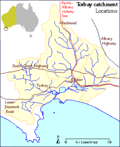
The Torbay catchment is on the south coast of Western Australia, and on the western outskirts of Albany. The catchment contains mostly rural land with just a few small settlements, the largest of which is Elleker (population about 100). Other settlements include Torbay, Torbay Hill, Redmond and Cuthbert. The Albany Highway is the main route connecting the region with the state capital, Perth.
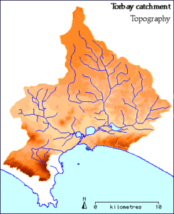 The ocean boundary of the catchment is characterised by the steep slopes and limestone cliffs of the coastal hills and contains the highest point in the catchment (around 300 metres). Between these steep slopes is the very recently accumulated dunal system. This is breached by outflow channels from Torbay Inlet and other small creeks. Beyond the hills is the low-lying Grassmere Valley, much of which is below 20 metres above sea level. The valley contains Torbay Inlet, Manarup Lagoon and Lake Powell. To the north of the catchment the ground rises gradually, incised by the Marbellup Brook and Seven and Five Mile Creeks.
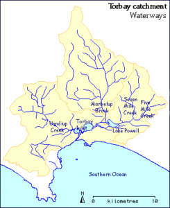 The Torbay catchment includes three main sub-catchments plus a small area of coastal drainage. The major streams, which normally only have significant flow in the wet winter months from June to September, drain through a series of shallow lagoons and man-made channels to the ocean via the neck of the Torbay Inlet. Unndiup Creek, a modified waterway (also known as the Torbay Main Drain), flows directly into the Torbay Inlet. A sand bar at the estuary mouth prevents ocean outflow most of year. This allows the water level in the lakes to rise above sea level when steam flows are low. Although the sand bar may break naturally, in most cases it is artificially breached when water threatens to flood adjacent farmland.
Marbelup Brook sub-catchment:125 square kilometeres (38%)
Five and Seven Mile Creeks sub-catchment: 60 square kilometeres (18%)
Torbay Main Drain: 115 square kilometeres (35%)
Coastal streams draining dunes: 30 square kilometeres (9%)
Total catchment area: 330 square kilometeres
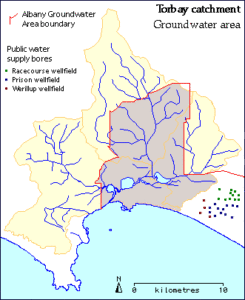 A significant area of the catchment is included in the Albany Groundwater Area. Designating groundwater areas allows the government to apply controls to land use and private extraction within the area to protect the quantity and quality of groundwater for public water supplies. Although the Water Corporation currently has a group of operating borefields sited just outside the southeast catchment boundary, there are at present no public water supply bores within the catchment. Private bores do exist in the catchment including inside the Groundwater Area. Groundwater is fresh, but supplies depend on local geology and soil type.
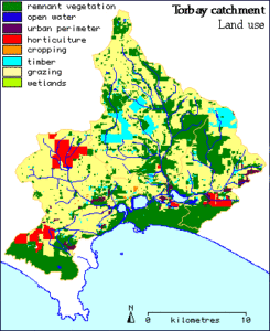 The majority of the catchment has been cleared and is used for grazing cattle. However, there are significant patches of remnant vegetation throughout the catchment, the largest tracts being West Cape Howe National Park and the coastal reserves. In recent years increasing areas of land have been planted with non-local eucalypts which provide timber for the wood-chip industry. Fruit and vegetables are also grown, mostly for the local market, and there are also dairies and piggeries in the catchment.
Remnant vegetation: 108 square kilometres (33%)
Open water and wetland: 5.2 square kilometres (1.6%)
Grazing:170 square kilometres (51%)
Timber Plantations: 17 square kilometres (5%)
Other land uses: 29.8 square kilometres (9%)
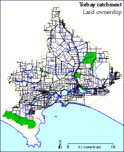 The estimated number of properties in the catchment is just under 600, with the typical size of a private rural holding being 100-150 hectares. The map shows national parks and wildlife reserves in green. The most significant of these is West Cape Howe National Park, in the southwest corner of the catchment, which protects spectacular coastal scenery and endemic vegetation, including the Albany Pitcher Plant. Much of the coastal strip and several inland areas are vested in the City of Albany and are maintained in their natural state.
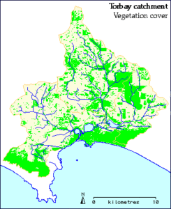 Remnant vegetation is scattered throughout the catchment. These areas vary from near to pristine to areas heavily infested with weeds. The large area to the south west is West Cape Howe National Park, other vegetated areas along the coast are mainly vested with the City of Albany. These all form part of the largely uninterrupted strip of vegetation stretching along the south coast of Western Australia. There has been widespread clearing of farming land; sometimes the only remaining treed areas are along roads and streams. There are also some significant stands of trees on private property.
Future increases in tree cover will come from tree plantations, fencing of remnant patches and streamlines, and revegetation by farmers. Losses are likely from further clearing and due to lack of recruitment in areas where stock have access and where weeds and pasture grasses have invaded.
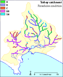 The major streams in the catchment have been assessed to determine the quality of the fringing vegetation and the erosion of the banks: Marbellup Brook (in 2000); Seven and Five Mile Creeks (in 2001); and the Torbay Inlet sub-catchment (2003).
A, B, C, and D grading is a widely accepted method of foreshore condition rating, based on the method developed by Dr Luke Pen who carried out surveys on many south coast rivers. Drain (DR) and pasture swale (SW) ratings have been included in subsequent foreshore surveys to take into account local differences in the topography.
A Grade foreshore – Pristine/near pristine/slightly disturbed. Native plants dominate. Complete native understorey and overstorey.
B Grade foreshore – Degraded. The native understorey is degraded and weeds start to dominate.
C Grade foreshore – Erosion prone and soil exposed and eroding. Some trees but little ground cover.
D Grade foreshore – Freely eroding ditch with no remaining fringing vegetation.
DR – Artificial drain varying in condition from excellent (resembling a healthy, natural vegetated watercourse) to very poor (severe erosion, slumping, and deposition with no vegetation cover).
SW – Pastured swale. The area above the stream headwaters where surface runoff collects and runs into stream channels.
The results are used to identify threats to the waterways, set priorities and plan remedial action.
